Hurricane Melissa live updates: Category 5 storm threatens Jamaica with devastation
Jamaica is bracing for what the National Hurricane Center said would be catastrophic flash flooding and landslides caused by up to 40 inches of rain.
What we know
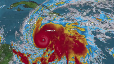
- Hurricane Melissa is edging toward Jamaica and is set to make landfall as a historic Category 5 storm, with winds of more than 170 mph.
- Jamaica is bracing for what the National Hurricane Center said would be catastrophic flash flooding and landslides caused by up to 40 inches of rain in some places. The storm is due to make landfall early tomorrow.
- Widespread damage to property and infrastructure is expected, and some people were already in storm shelters last night.
- The storm is expected to hit Cuba and bring severe weather to other parts of the Caribbean, including the Bahamas and the Turks and Caicos islands.
- Melissa is now the most powerful storm of the 2025 Atlantic hurricane season and is expected to be the strongest storm to hit Jamaica since Hurricane Gilbert in 1988.
- George Solis is reporting from Kingston, Jamaica, for NBC News.
Monster storm barrels toward Jamaica
Jamaica is bracing for a dangerous Category 5 hurricane, which could pack winds up to 175 mph and unleash up to 40 inches of soaking rain. Hurricane Melissa could be the strongest storm to ever make landfall in the country.
An estimated 50K without power in Jamaica as Melissa nears
Around 50,000 people are without power this evening, mostly in the western part of Jamaica, a government minister said.
Fire crews were responding to fallen trees as Hurricane Melissa approaches Jamaica as a Category 5 storm, Desmond McKenzie, Jamaica’s minister of local government, said at a briefing at 6 p.m. local time (7 p.m. ET)
The storm is forecast to make landfall tomorrow morning, forecasters said.
McKenzie encouraged people in flood-prone zones to seek shelter before it is too late.
Hurricane Melissa's intensity turned around a hurricane hunter flight
Hurricane Melissa is so powerful that it forced the National Oceanic and Atmospheric Administration’s Hurricane Hunter aircraft measuring the storm to flee because of extreme turbulence near the Category 5 storm’s eyewall.
“We had to leave a little early because of how turbulent it was,” said Andy Hazelton, a hurricane modeler and associate scientist with the University of Miami Cooperative Institute for Marine & Atmospheric Studies, who was on the flight. “It definitely felt like a roller coaster drop. I’ve been on some bumpy flights. It was the bumpiest I’ve been on.”
Hazelton was one of several scientists taking measurements during the Hurricane Hunter flight. He was processing data from dropsondes, which are instruments with parachutes that are dropped from the aircraft and into the storm.
Hazelton said that it was not the first time a Hurricane Hunter aircraft had been turned around but that it was relatively rare experience and that he recalled it happening only during “high-end” storms in the past, including Hurricane Ian.
“It was definitely interesting to see the power of nature, and it’s sobering to know it’s about to hit somebody,” Hazelton said.
Hazelton, who models hurricanes, said the storm has been fueled by anomalously warm waters in the Caribbean Sea. Heat is fuel to hurricanes. Typically, a storm this powerful would churn up cold water from beneath the sea surface; instead, it's churning up more energy.
Hazelton said researchers will be watching closely to see whether the hurricane goes through an eyewall replacement cycle, which could cause it to grow in breadth but slightly weaken its windspeed.
“It’s really going to be bad either way,” Hazelton said.
Hazelton helped develop NOAA’s next-generation hurricane modeling program, called HAFS. He was hired as a federal employee at NOAA’s Environmental Modeling Center last October, then fired during the Trump administration's mass cuts to NOAA's workforce in February.
Hazelton is scheduled to join another Hurricane Hunters flight tomorrow morning as the storm approaches the Jamaican coast. If the storm maintains its expected track, the mission will take some of the last measurements of the hurricane before landfall.
Melissa starting to turn north toward Jamaica
The center of Category 5 Hurricane Melissa has started to turn to the north, and that should bring it over southern Jamaica tomorrow morning, the head of the U.S. National Hurricane Center said late this afternoon.
The storm, south of the island nation, had been moving west, but it was now moving northwest with more turning expected, National Hurricane Center Director Michael Brennan said in a video briefing.
“We’re starting to see that turn to the north and then the north-northeast that’s going to bring the center of Melissa to the south coast of Jamaica early Tuesday morning,” he said.
The storm is expected to bring destructive winds along the eye wall and a storm surge of up 9 to 13 feet east of where it crosses land, “especially areas like the Black River Bay and farther east,” Brennan said.
The damage will not be confined to the coast; it will be in higher terrain as the hurricane moves across Jamaica, he said. Destructive waves and significant storm surge are expected all the way east to the Kingston area, he said.
“Everyone in Jamaica needs to be in their safe place now to ride out the storm, all the way through tomorrow,” Brennan said.
Government shutdown means no salary for National Hurricane Center employees
Federal hurricane hunters, modelers and forecasters won't receive pay for their efforts to understand Hurricane Melissa as the government shutdown continues.
“The National Hurricane Center employees are not being paid," said Tom Fahy, the legislative director of the National Weather Service Employee's Organization. "No one's been furloughed."
Fahy said all 3,800 National Weather Service employees are considered "essential workers" and are continuing their jobs without pay during the shutdown. The National Hurricane Center is a division of the National Weather Service.
Kim Doster, a spokeswoman for the National Oceanographic and Atmospheric Administration, which oversees the NWS, confirmed as much.
"The crippling federal government shutdown is making essential workers and service members go unpaid," Doster wrote in an email.
The federal government has been shut down for 27 days so far.
Jamaica PM: 'Entire world has been praying for Jamaica'
Jamaican Prime Minister Andrew Holness said today that he has been impressed with the calls from other leaders as the potentially devastating Category 5 hurricane approaches.
“I have gotten so many calls, and I have been on my knees in prayer,” Holness said at a news conference this morning.
“And I know that there are Jamaicans here praying for us, Jamaicans overseas praying for us, but more than that, it would appear that the entire world has been praying for Jamaica,” he said.
“I’ve gotten so many calls from leaders from all over the world, in particular CARICOM leaders who are all praying for Jamaica at this time,” Holness said, referring to the intergovernmental organization Caribbean Community.
The storm's center, which is south of Jamaica, is moving northwest, and it is expected to turn north.
U.S. citizen stranded in Jamaica with 11 family members
Georgia resident Peter Kong was visiting Jamaica when Hurricane Melissa became a major threat to the island, stranding him and his 11 family members.
They are staying at a hotel in Ocho Rios, where they plan to stay for the entirety of the storm, Kong told NBC News. Kong has been posting video updates of his experience being stranded on Facebook.
In a clip posted late last night, Kong and his fellow hotel guests form long lines as they wait to receive a bag of food supplies from the hotel.
But the distribution of the supplies was "so disorganized," Kong said, adding that "everybody wanted to just push forward and try to get what they could."
He and his family went out to get their own supplies and feel safe and prepared ahead of the storm. Kong’s biggest concern is the possibility of water rising to his hotel room balcony.
Yesterday morning, hotel guests were given a pamphlet outlining safety measures to take before the storm.
"Close the curtains and stay away from the balcony doors or windows," the pamphlet said. "Please place the mattress against the window or balcony doors for protection."
Kong has an American Airlines flight booked out of Jamaica on Thursday, which he said is the earliest option he could find.
How climate change is fueling rapidly intensifying hurricanes
Melissa's quick transformation from a tropical storm into a Category 5 hurricane is just the latest example of how climate change is fueling stronger, fast-changing storms.
Over the weekend, Melissa exploded from a 70-mph tropical storm into a 140-mph Category 4 hurricane in only 18 hours. It strengthened again overnight, reaching Category 5 status early this morning.
The term "rapid intensification" describes an increase in sustained wind speeds of at least 35 mph over 24 hours, according to the National Hurricane Center.
In recent years, scientists have observed an increased risk of storms' undergoing rapid intensification as a result of warmer-than-usual sea surface temperatures and high levels of moisture in the atmosphere. Both are hallmarks of global warming and are also key ingredients needed for storms to gather strength.
A 2023 study published in the journal Scientific Reports found that tropical cyclones in the Atlantic Ocean were around 29% likelier to undergo rapid intensification from 2001 to 2020, compared with 1971 to 1990.
There are numerous examples in recent memory: This year, Hurricane Erin's jump from Category 1 to Category 5 in a little over 24 hours made it one of the fastest intensifications on record. Last year, Hurricane Milton’s maximum sustained wind speed increased by 90 mph in roughly 25 hours. Other recent examples of rapid intensification include hurricanes Idalia in 2023, Ian in 2022, Ida in 2021, Laura in 2020, Dorian in 2019 and Harvey in 2017.
U.S. citizens in Jamaica should shelter in place, State Department warns
Americans in the path of Hurricane Melissa should plan to shelter in place as this "dangerous storm" targets Jamaica, the U.S. State Department said in a travel alert today.
"Catastrophic flash flooding and numerous landslides are likely. This is a dangerous storm," the alert warned. "U.S. citizens potentially in the path of the hurricane should be prepared to shelter in place throughout the storm."
"Contact your loved ones now to let them know where you are staying and how to best reach you," the State Department said.
Melissa continues slow crawl toward Jamaica
Hurricane Melissa is slowly moving closer to making landfall over Jamaica, the National Hurricane Center said in its 2 p.m. ET advisory.
The eye stands about 145 miles southwest of Kingston with maximum sustained winds of 175 mph — stronger than earlier forecasts that had the storm pushing 165 mph winds.
It is still moving west-northwest at 3 mph and is expected to turn north later in the day, the NHC said. This turn will determine where Melissa makes landfall.
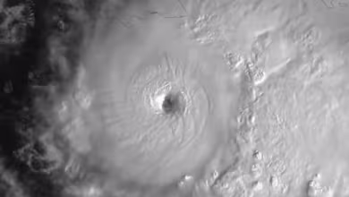
Satellite video shows lightning striking across the eye of the storm
Video posted by a research institute shows lightning that was flashing across the eye of Hurricane Melissa earlier this morning.
The images were shared on social media by Colorado State University's Cooperative Institute for Research in the Atmosphere, which works in partnership with NOAA.
Evacuations ordered for 6 high-risk areas in Jamaica
The government in Jamaica has issued mandatory evacuation orders for six areas it designated as high-risk as the island prepares for the high-powered hurricane.
Evacuations have been issued for people in Port Royal, Kingston; Portland Cottage, Clarendon; Rocky Point, Clarendon; Old Harbour Bay, St. Catherine; Taylor Land, Bull Bay, St. Andrew; New Haven, St. Andrew; and Riverton City, St. Andrew.
Members of the Jamaica Constabulary Force are prepared to assist with evacuations, according to the Office of Disaster Preparedness and Emergency Management.
Forces are ready to deal with 'looting' and 'law and order,' PM says
Jamaican Prime Minister Andrew Holness said security forces are in place to "prevent any break in law and order."
He warned at a news conference of those looking to break the law and capitalize on natural disasters, and he urged Jamaicans to protect themselves.
"The security forces, they are properly mobilized, and they understand how we should posture in this disaster," Holness said, adding, "The rights of citizens must be respected."
He urged Jamaicans to stay inside, calling it "the safest place to be at the moment," and to avoid "looting and other kinds of antisocial behavior," including throwing parties and playing football in the rain.
Jamaican official: 'Almighty Father, spare us'
"I'm moving away from saying good morning, and from now, until whenever we recover, I will just say, 'Almighty Father, spare us,'" Daryl Vaz, Jamaica's minister of energy, telecommunications and transport, said as he opened his portion of a news conference.
He went on to give updates about the island's transportation systems.
All airports will remain closed until Hurricane Melissa has passed, Vaz said. All bus service has also been terminated until after the storm. He said the government has school buses available and ready to use should they need them for any reason.
"Keep faith, keep strong, and know that you have a government that is going to be there for you, with you," Vaz said.
He added a warning: "But you need to be smart. If you’re smart, we can work together. If you are not, unfortunately, you will pay the consequences. This hurricane is real."
Officials warn of fake videos and misinformation during Melissa
At a news conference held by Jamaican officials this morning, Dana Morris Dixon, the country's minister of education, skills, youth and information, noted that those giving updates will "give you the information, the correct information."
She said she has seen fake videos of Hurricane Melissa, many of which are coming in through a number of WhatsApp groups Morris Dixon said she was personally a part of.
She urged Jamaicans to listen to official channels to get correct updates and to try to avoid videos posted online that might not be accurate.
Matthew Samuda, minister of water, environment and climate change, urged Jamaicans to listen to instructions from officials, especially in reference to evacuation orders, because misinformation is already circulating.
False reports of which areas are flooded can "hamper evacuations" and can prevent people from "trying to get out of harm's way," Samuda said.
Around midday today, Samuda said officials will start publishing updates every three hours that citizens can follow. He said systems are already being impacted, and updates will let people know what they need to.
A third official — Desmond McKenzie, minister of local government and community development — warned again of misinformation, this time in relation to storm shelters.
He said he has seen "false and malicious" information floating around that fees are being charged to use shelters set up by the government on the island.
McKenzie called that "nonsense" and "mischief that is being made" and confirmed that isn't the case.
"What is happening is that there is an attempt by persons with bad intention to create confusion at this time," McKenzie said adding, "the country doesn't need confusion at this time."
Melissa inches closer to Jamaica, becomes strongest hurricane of the season
Melissa is now about 145 miles southwest of Kingston, moving at a pace of 3 mph as it slowly approaches Jamaica, where it is expected to make landfall early tomorrow as a Category 5 storm.
Winds are up to 165 miles per hour with higher gusts, as of the National Hurricane Center's 11 a.m. ET update. It has strengthened compared to earlier this morning. The pressure continues to drop, meaning additional strengthening is possible through the day. Hurricane-force winds are extending just 30 miles from the center.
Melissa is now the strongest hurricane of the 2025 Atlantic season. Both Erin and Humberto reached maximum winds of 160 miles per hour.
It is expected to turn north later today and bring life-threatening winds, floods and storm surge to Jamaica tonight and into early tomorrow. That northward turn is expected to occur by this afternoon or evening, and when it makes the turn will determine the landfall point on the island.
Jamaica remains under a hurricane warning, with the southeastern and central Bahamas and the Turks and Caicos islands under a hurricane watch.
"Melissa is expected to reach Jamaica and southeastern Cuba as an extremely powerful major hurricane, and will still be at hurricane strength when it moves across the southeastern Bahamas," the hurricane center wrote in the latest advisory.
At least 15-30 inches of rain is expected in Jamaica, with up to 40 inches possible on the Caribbean island.
Melissa would be the first Category 5 storm to make landfall in Jamaica
If Melissa makes landfall as a Category 5 hurricane, which it is currently forecast to do, it will be the first Category 5 to make landfall on Jamaica, and therefore the strongest hurricane to ever make landfall on Jamaica.
Before Melissa, the strongest hurricane to strike Jamaica was the 130-mph Category 4 Gilbert in 1988.
Melissa became the third Category 5 of the 2025 season. The last time there were more than two Category 5 storms in the same season was 20 years ago in 2005.
Jamaican PM shares update ahead of Melissa landfall
Jamaican Prime Minister Andrew Holness gave an update on Melissa in a video shared to social media this morning.
He said hurricane conditions are expected to linger over Jamaica due to the storm's slow-moving nature, leading to extended rainfall and expected flash flooding throughout the island.
The massive precipitation will trigger landslides in hilly areas, he said, and he warned that buildings and activities in or along those areas "will be at high risk of damage, complete displacement and loss of life."
Winds are expected to damage roofs and structures throughout the island, Holness added.
"While we pray for the best all by all, it is becoming apparent that the impact of Hurricane Melissa could be greater than Hurricane Beryl, certainly in terms of rainfall and flooding," he continued. "We can lessen damage and speed up recovery by taking preparatory and precautionary measures before the impact of the hurricane."
He called on those living in vulnerable areas to take precaution and to prepare an evacuation plan. All Jamaicans should avoid hazardous activities such as playing in floodwaters and climbing trees.
Instead, Holness said, Jamaicans should shelter in place.
"Stay inside during the hurricane. We have issued an order under the disaster risk management act declaring the entire island of Jamaica a threatened area," Holness said. "This provides us with the legal framework to take all necessary measures to safeguard lives and property during the hurricane."
Holness said he signed a "compulsory evacuation order for several communities along the south coast, which will empower authorities act as necessary to have persons evacuated from high-risk areas to save lives."
He also said he issued an order under the trade act to prevent price gouging.
"No one should seek to profit from the hardship of a disaster," Holness said.
He concluded his address with a call to the citizens of the island.
"My Jamaican family, we will weather this storm, and when the sky is clear, we will come together to restore and build stronger, prouder and more resilient than before," Holness said. "Keep safe, everyone. May God bless you, protect your families and keep safe our beloved Jamaica land, we love you."
Melissa went from 70 mph winds to 140 mph in just 18 hours
This morning, Melissa became a rare and powerful Category 5 hurricane. Over the weekend, it went through extreme rapid intensification, exploding from a 70 mph tropical storm to a 140 mph Category 4 hurricane in just 18 hours.
As of 8 a.m. ET, Melissa has winds of 160 mph. It is located 135 miles southwest of Kingston, Jamaica, and is moving west at 3 mph.
Hurricane-force winds extend 30 miles out from the center, while tropical-storm-force winds extend 195 miles.
Tropical storm conditions have already begun across Jamaica, with hurricane conditions expected by tonight.
Some additional strengthening is possible today as Melissa makes the slow turn to the north. Landfall on western Jamaica is expected early tomorrow as a Category 5.
Beyond Jamaica, Melissa will make another landfall on southeast Cuba, west of Santiago de Cuba, as a major Category 3 hurricane early Wednesday. It is forecast to remain a Category 2 hurricane as it crosses the Bahamas and maintain hurricane strength when it passes near or over Bermuda early Friday.
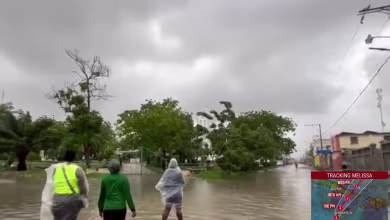
Social media showing heavy rain and winds in Jamaica
As Jamaica braces for the worst effects of Hurricane Melissa later today and into tomorrow, some are already experiencing heavy rain and winds according to footage uploaded to social media.
A coconut tree sways in the wind at the Kingston Waterfront on Sunday. Ricardo Makyn / AFP via Getty Images
Trees were swaying heavily near Kingston and it was already raining intensely.
U.S. tourists get caught up in Hurricane Melissa
KINGSTON, Jamaica — An American tourist who caught one of the last flights off of the island said there was a lot of turbulence getting back to the U.S.
“It was almost like getting out and watching the rain come behind us,” he said. “But luckily we made it.”
Others weren’t so lucky. Nicole Doyon, from Miami, was visiting the island for a yoga retreat, but can’t get out before the storm after exhausting all of her options.
“There was nothing available. At this point, there are no options,” Doyon said.
Hurricane Melissa intensifies to Category 5 storm, threatens Jamaica with ‘catastrophic’ flooding
Hurricane Melissa intensified to a powerful Category 5 storm early today as forecasters warned it would cause catastrophic flash flooding, life-threatening landslides and extremely strong winds across the Caribbean.
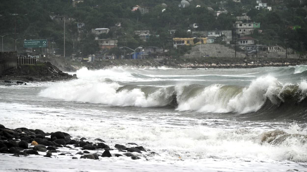
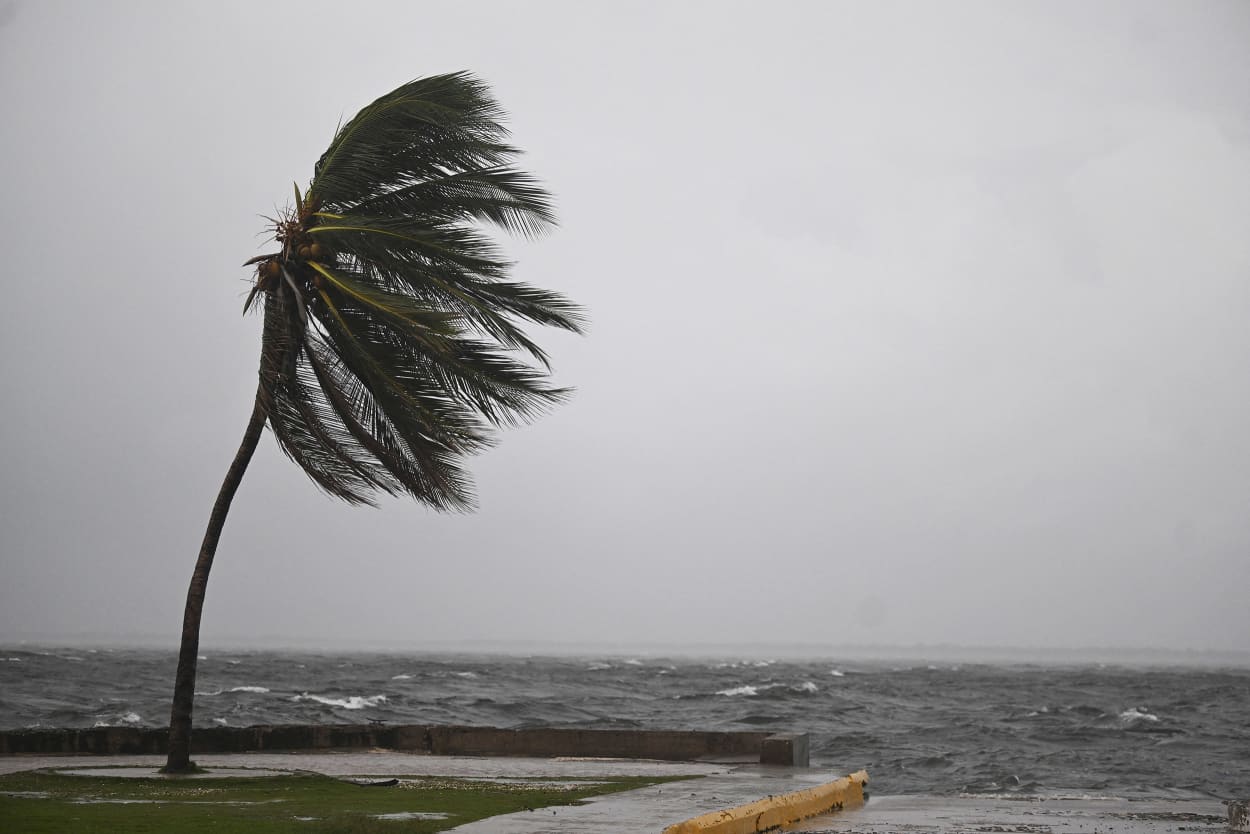
A storm surge before the arrival of Hurricane Melissa in the Caribbean Terrace area of Kingston, Jamaica, on Saturday. Ricardo Makyn / AFP via Getty Images
The U.S. National Hurricane Center in Miami warned people in Jamaica to go to shelters and stay there during the storm, with dangerous conditions beginning today and lasting through tomorrow.