Science
The latest science news, photos and videos covering space, the environment, human development and more.
LATEST SCIENCE NEWS


TOP VIDEO


In case you missed it
90 degrees in October: Dozens of heat records could be broken in the Midwest
Temperatures across the region are expected to be up to 30 degrees higher than normal Friday and Saturday.

$1M worth of coins recovered in Spanish shipwreck off Florida coast, treasure hunters say
The coins are part of the $400 million in worth of gold, silver and jewels lost in a 1715 Spanish shipwreck, the treasure hunters claimed.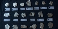

Climate change
Swiss glaciers shrank 3% this year, the fourth-biggest retreat on record
More than 1,000 small glaciers in Switzerland have already disappeared, experts said.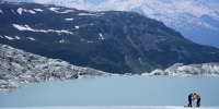

Jane Goodall, renowned chimpanzee researcher and animal advocate, dies at 91
Goodall, who was 91, became famous first for her pioneering observations of chimpanzees in Tanzania.

Jane Goodall in photos: Her legacy as a chimpanzee researcher and animal rights advocate
The lifelong wildlife advocate died at age 91.

An asteroid might be heading for the moon. Should we nuke it?
An asteroid known as 2024 YR4 is estimated to have a 4% chance of hitting the moon in 2032. A new paper explores whether to nuke or deflect it.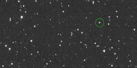

Saudi Arabia
Scientists find ancient life-size animal rock carvings in the Saudi Arabian desert
The rock art was used to mark the location of water sources in an illustration of how ancient people tackled some of Earth’s most inhospitable environs.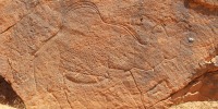

In South Texas, a town struggles for water
The city of Mathis is scrambling to find alternative sources of drinking water as severe drought threatens to dry up its main supply.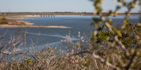

Ancient skull from China may shake up timeline of human evolution
Researchers used sophisticated scanning and digital reconstruction techniques to determine the original shape of the skull.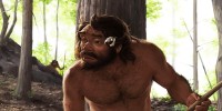

Lasers, fiber optics and tiny vibrations tease a way to warn about earthquakes
Scientists were able to use the data from a fiber optic cable and a sensitive measuring device to “image” the Mendocino earthquake – determining the magnitude, location and length of the rupture.

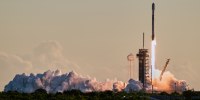
A trio of space weather satellites blast off together to study the sun's violent side
The goal is to better understand the sun in order to better protect Earth.